
“I kind of feeling like doing an adventure tomorrow but I don’t want it to be too hard,” Heather texted Jill.
“Adventure sounds fun,” replies Jill (Jill is always up for adventure).
A few hours later…
“I’m trying to think of a fun adventure, unsuccessfully,” Jill says.
The next day dawns, and Heather awakes with a scratchy throat and feeling a little run down.
“I didn’t come up with anything. I’m not feeling as adventurous this morning,” Heather states. She continues, “I was thinking our adventure could be finding a bakery and sharing a treat.”
Jill replies, “That sounds yummy. I like that type of adventure.”
Heather jokes, “Better than say, 21% grade, which is all I could come up with. And our pictures would be of us falling over, with snakes, and walking our bikes.”
But somehow, Jill takes that part about the 21% grade seriously, and somehow, 21% grade becomes the plan.
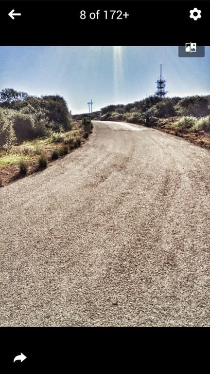
So, some explanation here. “21% grade” is an off-road, paved trail that leads up to the radio tower above San Marcos, CA. I’m not sure who first called it “21% grade”, because it’s not even an average of that grade (more along the lines of 15%, but at those grades, who’s counting), but that’s now what we call it. I’m not sure if it has a real name. If you’re in or near Lake San Marcos, find Double Peak on the horizon, then look toward the right to find the radio tower – then look for the really steep looking path that leads up to it. You have to meander back through the wilds of Lake San Marcos, where every road is potentially a dead end, in order to find the start. It looked a little different to me this time because the road has actually been widened.
I had attempted this hill four times in the past, all prior to my lengthy forced rest period. The second and third times I tried, I was extremely determined to finish without walking (or so I had thought), but the last ramp always seemed to do me in, and there I’d be, clomping up the road bent over at about 90 degrees, dragging my bike up to the top where David awaited me (with time to clean his nails, have a snack, and maybe invent something or other). With struggling on steep hills ever since returning to the bike in November, I didn’t think there was a much of a chance I’d succeed at staying on my bike up this beast (at least, not anytime soon).
On paper, this route maybe doesn’t seem so bad. In reality, it feels like relentless climbing. Beginning at my house off Rancho Santa Fe road, you begin with relatively gentle, but fairly continuous, climbing all the way out to Lake San Marcos, where you get a tiny rest before the suffering begins. The worst of it is “only” about a mile long, but you’re looking at a mile where the very best men’s time on Strava is around 8mph, and all but the top 6 riders who have done this have not achieved over 7mph average. It’s most likely best to not look at your garmin – maybe even put it in your pocket – you don’t want to know the grade, and you don’t want to know your speed. It’s slow, that’s all you need to know.
After the first bit of ramp, unfortunately for you, there’s a rather substantial gate that I feel like they’ve somehow made more difficult to get through since the last time I was there. I slid my bike under the gate, and somehow went over it, and then you have to clip in and resume the climb – fortunately, that’s the only place that happens on this portion. Somewhere along the line I forced myself to learn how to clip in on a hill. David claims I couldn’t always do that, and surely I couldn’t, but I can’t remember that anymore. I didn’t want to pause too long to let any doubt creep in, and so I headed off – slowly but surely up to the first bend in the road. This is the easy part. Enjoy it.
In case we got separated, I told Jill that there would be a point where it appeared to level off, and you will have a choice to go straight on what looks like a much easier path, or turn left on what looks like it might be horrible. You must turn left there, no matter how much you want to go straight!
I also told her that at no point does it get easier after that point, in fact, it pretty much only gets harder. I’d tried to convinced myself in the past that it got a little easier not long after that turn – and that was the wrong thing to convince myself of. It always ended in unclipping and clomping. “It does not get better – ever – not until you are at the towers. Stay calm and steady.”
I’m not sure if the path was always that wide, because I thought I had remembered it not being wide enough to “paperboy” (i.e., zig zag across the path, making a tiny switchback path out of a straight up one). But I noticed it was wide enough, and I employed the paperboy – almost unsuccessfully because some of the path edge was a little gravelly and I slid a bit. I gripped the handlebars and used all the upper body strength I could muster to stay straight. I truly nearly lost my nerve when I hit the last hard ramp and I knew I didn’t have the strength to stand – but I’d come too far to lose now. In my mind, I was thinking, “Just … **wheeze** … like **wheeze** … leg press … **wheeze** at … the ..**wheeze**. gym … with .**wheeze**.. a … little lat pull thrown in…
Also going through my mind as I kept looking back for Jill when a turn presented a view was the fact that I hadn’t seen or heard Jill since the gate. I was being all self-consumed with finishing the hill, what if poor Jill was in a heap with her bike by the gate with a rattlesnake about to strike, and here I am just worried about getting to the top? Well, I said to myself, just get up to the top of this monster and then you can start returning back down a bit and looking for Jill.
After I made it to the top, did a little victory dance and selfie posing (there might’ve been some shouting also), I very hesitantly started descending the beast. I mean, surely she’d be here soon, and well, just because I did it once in my lifetime doesn’t mean I want to do it again anytime soon (no less the same day). I mean, surely she was fine.
And … she was. Not long after, I heard some clomping and so I shouted her name and she answered, and so I felt very relieved that Jill wasn’t in a heap somewhere (and also that I didn’t have descend very far). We mentally regrouped, and headed off on the Ridgeline trail that would take us to two more gates that would require clipping in on steep hills, and would eventually take us to finish on Double Peak. You would like to think the ride gets easier from here on out, but, well, while there are some flattish portions, it doesn’t. There are a few nasty ramps on the Ridgeline trail, and unless you are one of the cycling gods, Double Peak NEVER seems to get easier. Jill said as she finished up the last portion by the water tower, “I thought when you said we were finishing on Double Peak that this trail would come out AT Double Peak, not that I’d have to ALSO climb Double Peak!!”
Jill said that might be the hardest hill she ever did (and she’s done some hard hills). Probably not worse than Nate Harrison, but up there.
I suggested that before we seek out a delicious treat, we ease up on our legs and do some flatter miles to work out the kinks before sitting and gorging ourselves. After ~1800ft elevation gain in the first 8 miles, we finished up the 25-miler with 17 miles and about 850 ft of gain before settling in at the new Susie Cakes across the street from me where Jill spotted a multi-layered old fashioned chocolate cake that she just had to have (as did I). We ended up with our adventure after all.

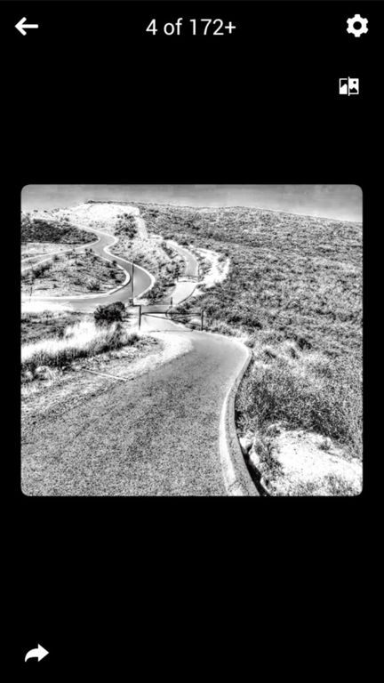
Looking down one of the ramps near the top. It’s too bad you can’t see that view when you are climbing.
View of the ramp up – this might be the worst one.

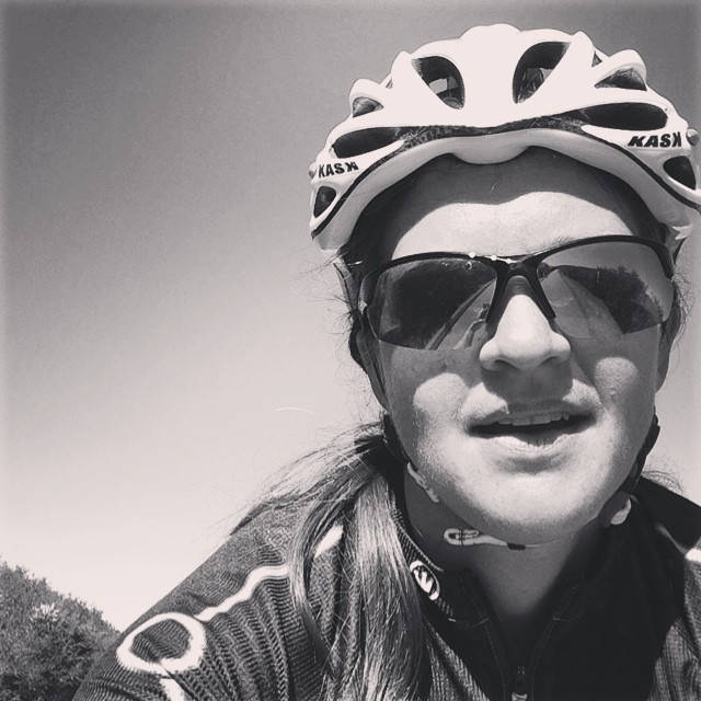
Me shouting victory at last, at the radio towers. I wasn’t sure I’d ever be able to make it.
Riding across the Ridgeline on a less hideous portion – I think the photo effect somehow removed all the sweat dripping off my face. Did I mention it was 90 degrees?
View down one of the worst parts of the Ridgeline trail – with gate

Jill captured a shot of me going up one of the ramps on the Ridgeline trail.

The gentle part of the Ridgeline trail, where you catch your breath and let some of the lactic acid out.

Jill and Heather at the top of Double Peak – 8 miles, 1800 ft, 90 degrees

And last, but certainly not least, the old-fashioned chocolate cake at Susie cakes!

Marvelous! 😀 You gals totally earned the cake after slaying that gory steepie monster!